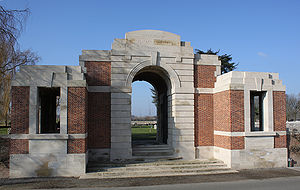
Lijssenthoek Military Cemetery
| Lijssenthoek Military Cemetery | |
|---|---|
 | |
| Country: | Belgium |
| Location: | West-Vlaanderen |
| Coordinates: | |
| Type: | Public |
| Owned by: | Commonwealth War Graves Commission |
| Number of gravesites: | 9877 |
| Website: | Lijssenthoek Military Cemetery |
The Lijssenthoek Military Cemetery is located west of Ieper (Ypres) Belgium. It contains burials from the Great War including 1058 Canadians.
History
During the First World War, the village of Lijssenthoek was situated on the main communication line between the Allied military bases in the rear and the Ypres battlefields. Close to the Front, but out of the extreme range of most German field artillery, it became a natural place to establish casualty clearing stations. The cemetery was first used by the French 15th Hopital D'Evacuation and in June 1915, it began to be used by casualty clearing stations of the Commonwealth forces.
From April to August 1918, the casualty clearing stations fell back before the German advance and field ambulances (including a French ambulance) took their places.
The cemetery contains 9,901 Commonwealth burials of the First World War, 24 being unidentified. There are 883 war graves of other nationalities, mostly French and German, 11 of these are unidentified. There is 1 Non World War burial here.
The only concentration burials were 24 added to Plot XXXI in 1920 from isolated positions near Poperinghe and 17 added to Plot XXXII from St. Denijs Churchyard in 1981.
Eight of the headstones are Special Memorials to men known to be buried in this cemetery, these are located together alongside Plot 32 near the Stone of Remembrance.
The cemetery, designed by Sir Reginald Blomfield, is the second largest Commonwealth cemetery in Belgium.
Location
Lijssenthoek Military Cemetery is located 12 Kms west of Ieper town centre, on the Boescheepseweg, a road leading from the N308 connecting Ieper to Poperinge.
From Ieper town centre the Poperingseweg (N308) is reached via the Elverdingestraat, then over two small roundabouts in the J. Capronstraat. The Poperingseweg is a continuation of the J. Capronstraat and begins after a prominent railway level crossing.
On reaching Poperinge, the N308 joins the left hand turning onto the R33, Poperinge ring road. The R33 ring continues to the left hand junction with the N38 Frans-Vlaanderenweg. 800 metres along the N38 lies the left hand turning onto Lenestraat. The next immediate right hand turning leads onto Boescheepseweg. The cemetery itself is located 2 Kms along Boescheepseweg on the right hand side of the road.
"We Rest Here"
The following members related to Signals are buried here.
| Headstone | Service Number | Rank and Name | Grave Location |
|---|---|---|---|
| 500288 | Sapper L Coop | VIII. A. 25A. | |
| 107 | Sapper HT Edwards | VI. B. 19. |